
By: Cludia Frey
 Claudia Frey was born in Stuttgart, Germany in 1951. She graduated with a degree in microeconomics and later worked as a manager for market information at Frankfurt-based VDMA for 40 years. She loves traveling and Iran is the 54th country she’s visited.
Frankfurt to Toronto
Originally scheduled for last year, the journey was cancelled due to the strict Corona regulations in Canada. This year, however, it came true and started in late May. Toronto is the biggest city in the second largest country in the world. With around 3 million inhabitants, 6 million in the Metropolitan region, it is the capital of Ontario, one of Canada’s provinces and territories. Ontario’s territory is three times the size of Germany, just to give an impression. Toronto lies on the shores of Lake Ontario, on the same latitude as Bucharest in Romania.
Unfortunately, part of my 1.5-day stay in downtown Toronto was bothered by pouring rain, which prevented the visit to the lakeshore and a boat trip. Going up the CN Tower as planned would have meant burning money. Nevertheless, I remember very impressive museums, an obviously lively art scene, lots of theatres, film studios and an interesting architectural mix of old and new.
Toronto to Niagara Falls and back
When in Toronto, a trip to the Niagara Falls is a must. The excursion takes you 120 km along the shores of Lake Ontario through one of Canada’s wine and fruit growing regions, to the South-East tip of the lake, where it meets Lake Erie.
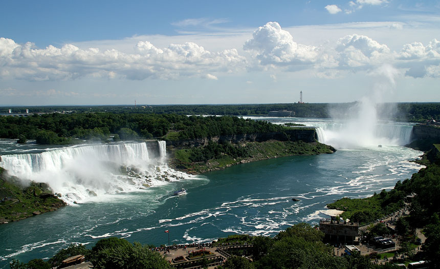
The latter, like the rest of the Great Lakes, is located up on the Great Escarpment. Lake Erie’s waters falling to Ontario’s elevation yield the world-famous Niagara Falls and the strait between Canada and the USA becomes Saint Laurence Stream.
The falls are an awesome spectacle, especially the Horseshoe Fall on the Canadian shore. It carries so much water that there is no need to take a boat to get wet from the spraying water. The small town of Niagara Falls hosts a permanent fun fair, which seems to be as attractive as the falls to some visitors.
Toronto to Vancouver
Early Sunday morning, there was a train to catch at Toronto’s lovely old-fashioned central station. VIA’s train No.1, the famous Silver and Blue Train dubbed The Canadian, covered 4.500 km in four days and four nights across four time zones and provinces of Ontario, Manitoba, Saskatchewan, Alberta and finally British Columbia.
There were major stops scheduled in Winnipeg, Saskatoon, Edmonton, Jasper, and Kamloops and many more halts to let cargo trains pass; trains with more than 200 trailers, mostly carrying containers on their way from the harbors on the Pacific Coast to the big cities in the East.
The train was constructed in the 50’ and has no Wi-Fi. Access to internet is scarce in remote areas. To make up for this flaw, the food served for breakfast, lunch and dinner is fantastic.
Shortly before the train stopped in Jasper, I spotted a black bear for the first time in my life. Sitting leisurely on its back on a slope close to the railroad tracks, the bear watched the 1 km long train pass by. Mission Part 1 was accomplished. A bear! I admit I was close to tears. Luckily, there were more black and brown bear sightings later, but no grizzlies showed up.
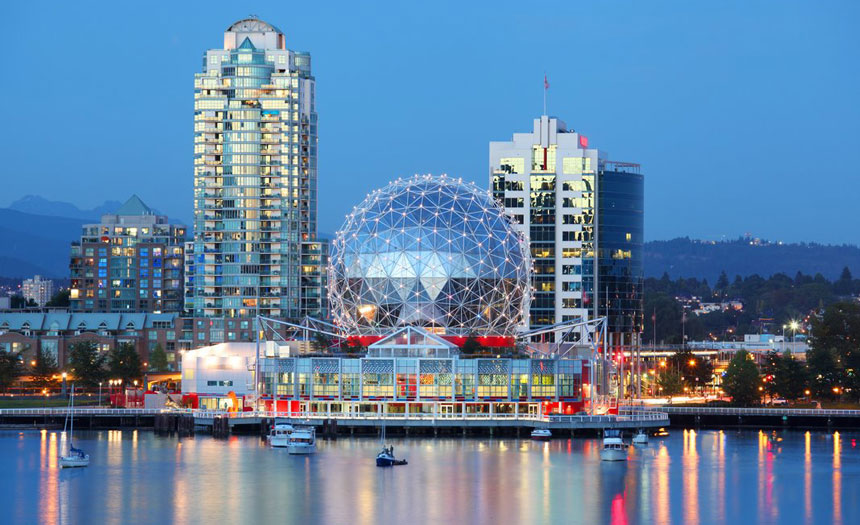
Vancouver
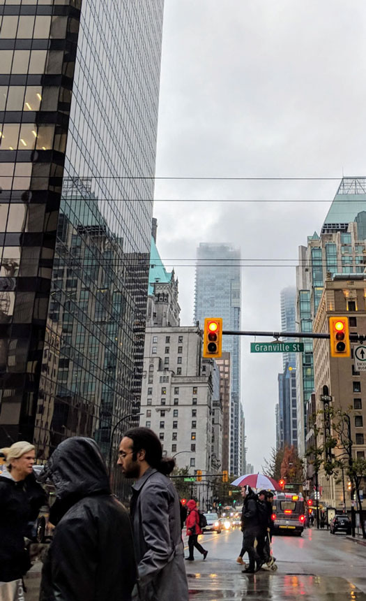
The city is believed to be one of the most beautiful, loveable, and livable places in the world. The city center, business district and most touristic spots are located on a peninsula surrounded by the Pacific Ocean and shielded by the snow-covered Coast Mountains.
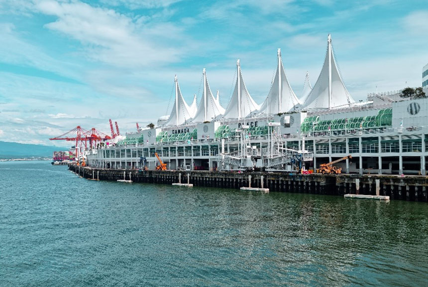
I spent three most enjoyable days walking and using the clean and efficient public transport, which included the sea Bus and the driverless metro. For those with a bigger wallet, there are also helicopters and seaplanes departing from downtown as means of transport. From the Canada Place Pier, cruise ships set sail mostly for trips through the Inside Passage to Alaska.
Vancouver to Olive
There are other articles written by Ms. Claudia Frey, If you enjoy this, you probably like to read the other ones too. Here is the link .
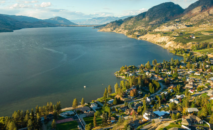
After this stay, I met my travel companions for the two-week Western Canada tour; 6 German and Swiss tourists and Denise, a 23-year-old driver/ guide. On the first and second day, we went through BC’s southwest, close to the US border. The landscapes we crossed were unexpected. A semidesert with little rainfall, the Okanagan Valley, which is famous for its wines and orchards, is warm and sunny. Near Olive, we visited one of the many vineyards and tried some of their tasty products, which have made their way to wine-lovers in the US and other continents. Dinner was served on a terrace overlooking the fertile valley.
Olive to Revelstoke
Via Penticton and Kelowna and amidst the lovely landscape, we headed along Lake Skaha, reaching Lake Okanagan, both more than 200 km long. An area of land made for long weekends and holidays, it sports a great variety of campgrounds and RV grounds. Shortly before Revelstoke, we passed the place in the Monashee Mountains where the last spike was driven in late 1885 to complete the Canadian Pacific Railway, ocean to ocean. In Revelstoke, a small nice wild-west-style town, I finally enjoyed the first Poutine for dinner. The French fries topped with cheese curds and gravy is said to be a symbol of Québécois and Canadian cuisine and culture. Must be a horror to true foodies, but it is filling and a local experience.
Revelstoke to Canmore (Banff)
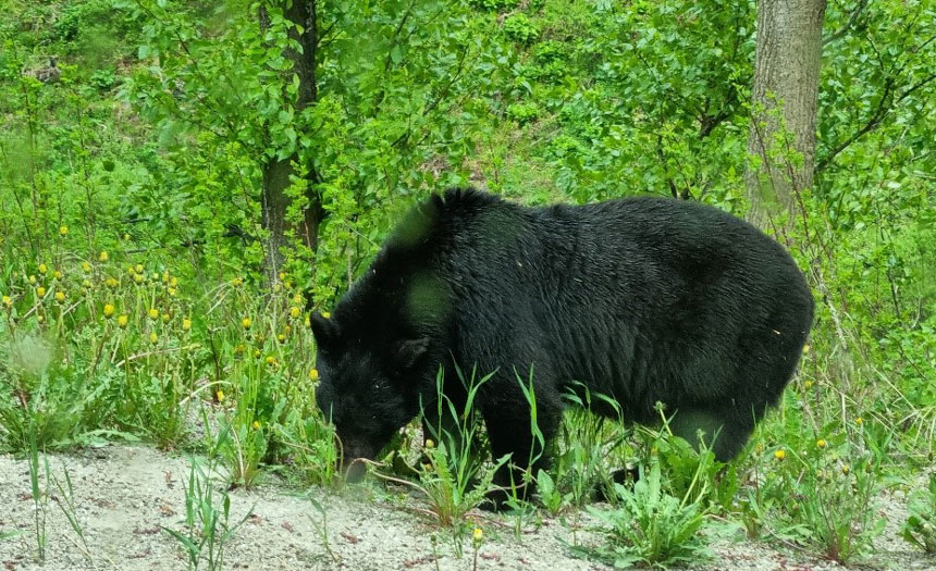
It was a long day on Highway 1, the Trans-Canada-Highway, through Revelstoke and Glacier National Parks, over Rogers Pass and crossing the Columbia Mountains. The highlight of the day was certainly a black bear close to the road, feeding on dandelions for breakfast. It was amazing to watch the huge animal meticulously pick the yellow petals, ignoring the bitter green leaves. In Golden we stocked up our picknick supplies for the next days and then passed Yoho National Park. At Kicking Horse pass, we saw a wapiti deer lying on a sandbank. A one-hour walk around Emerald Lake left us soaked by rain and dirty, but happy.
Banff
Finally, all the mountains around us are the true Rocky Mountains. We spent a whole day in different parts of Banff National Park. First stop early in the morning was said to be the most photographed place on earth, the magnificent Lake Louise at 1734 m. The turquoise-coloured glacial lake is surrounded by a mountain, with glacier backdrop mirrored it its waters. A real hiking and skiing paradise, it attracts visitors from all over the world. Eleven kilometers up the road through winter conditions in early June, lies enchanted Lake Moraine. At 1880 m, it is still covered with ice. Lunch pick nick was in Bow Valley, where many famous Hollywood movies, such as Brokeback Mountain and The Revenant, have been filmed. We had a great walk in the superb Johnston Canyon to the breath-taking waterfalls and back. A visit to the famous Banff ended the day.
Canmore to Jasper
The Icefield Parkway led us from one famous national park to the next. The highway is 232 km long and considered one of the world’s dream roads. The dream is made of lakes, mountain peaks, glaciers, and waterfalls. It follows the Rocky Mountains’ crest and goes across several passes as well as the 300 km2 Columbia Icefield. Glacial waters in breath-taking colors produce the great Sunwapta Falls. The Athabasca Falls are even more spectacular. This leg of the journey was a true sensational experience. Late in the afternoon we reached Jasper, a lovely small town, where early next morning I had a deja vu with another Canadian train, stopping on its way to the coast.
Jasper to Prince George
Crossing Yellowed Pass, Mount Robson Park was the next destination. At 3954 m, Mt. Robson is the highest peak of the Canadian Rockies and infamous for covering its summit most of the year, as it did when we arrived. Having seen the mountain from the train two weeks earlier, I was the lucky one. Along the mighty Fraser River, we headed to the next stop. On our way, we encountered another black bear rather close to the road rubbing its back on a pole, demonstrating its sheer size.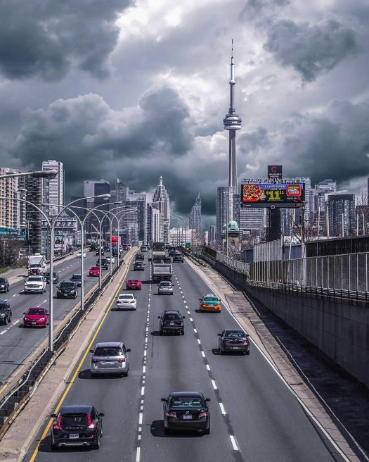
Prince George to Smithers
A 100 km detour took us to Fort St. James, one of Hudson Bay Company’s important trade posts, today a well preserved National Historic Site. Park employees wearing traditional clothing knowledgeably showed and told what life for trappers and fur traders in the 19th century was all about. A chicken race was the highlight of our Sunday morning, when we placed our bets on our favorite hens. Later we spotted a mama bear with three cubs almost hidden in high grass. Several moose crossed the street and disappeared in the woods.
Smithers to Prince Rupert
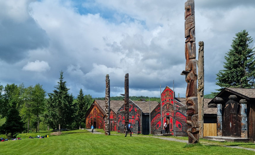
We now followed the wide Skeena River, which empties into the Pacific Ocean close to Prince Rupert. We visited ‘Ksan Indian Village, an openair museum run by the Gitksan First Nation. A clan member accompanied us to and through seven rebuilt long houses. She explained traditions like the Potlach and the symbolism of artfully carved totem poles.
Smithers to Prince Rupert
We now followed the wide Skeena River, which empties into the Pacific Ocean close to Prince Rupert. We visited ‘Ksan Indian Village, an open-air museum run by the Gitksan First Nation. A clan member accompanied us to and through seven rebuilt long houses. She explained traditions like the Potlach and the symbolism of artfully carved totem poles.
Prince Rupert to Port Hardy
A very short night was followed by a long, peaceful day. Close to the Southern border with Alaska, we boarded the car ferry to take us to Vancouver Island.
It was a 15-hour boat ride through the beautiful famous Inside Passage, a waterway through impressive nature. The confusing meander was made of densely wooded islands and rocks, channels, and fjords, and every now and then a lone fishing boat was to be seen. Only once did the ferry stop near a First Nation’s village. First row in a comfy lounge seat was a great place to enjoy the stunning views. The hours quickly passed and shortly before midnight, we reached Vancouver Island. Mission 2 failed yet; no orcas sighted.
Travel is always fun and full of new experiences, If You think so, lets check this link to see more.
Port Hardy to Victoria via Campbell River
Roughly 450 km long and 100 km wide, Vancouver Island is the largest island in North America. It seems like Canada in miniature with the sea, snow-capped mountains, lakes, black bears, orcas and whales, deer and racoons and beautiful beaches including the surfers’ paradise Tofino.
We tried salmon and scallops by Campbell River, which is known as the salmon capital of the world, tasted the famous calory-laden Nanaimo bars, visited Cathedral Grove, the ancient rainforest hosting century-old Douglas Firs and Giant Cedars, and admired murals in Duncan and more totem poles. We went on a several-hour whale watching tour, with dolphins and porpoises accompanying the boat and performing a stunning water ballet. The tour was graced by humpback whales, but mission orcas failed again.
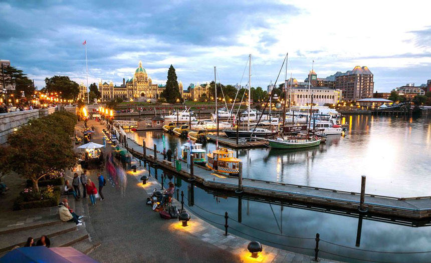
Victoria finally! Not only is it the island’s largest city, but also the capital of British Columbia. As the name promises, it is a lovely place with the charms of Victorian times. After 3.575 km by bus through Western Canada, a ferry from Swartz Bay took us back to Tsawwassen on mainland. I stayed on deck watching out for orcas, but mission orcas remained unaccomplished. Nevertheless, it was a great journey in a gorgeous country.